PAYNESVILLE, Liberia — The Liberian Geographical Society (LGS) has called for greater national investment in geographic information systems (GIS), stronger protection of spatial data and closer collaboration among government, academia and the private sector, warning that fragmented information systems and dependence on external actors are undermining Liberia’s development planning.
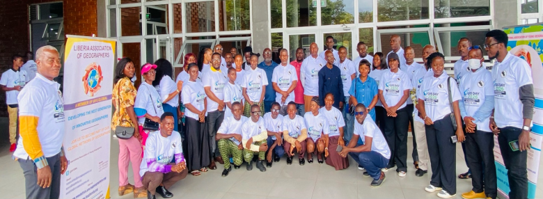
The call came Wednesday during the Society’s 2026 Geography Awareness Week and GIS Day celebration at the Liberia Learning Center, Paynesville Town Hall. The event brought together high school and university students, professors, government officials and GIS professionals to discuss geography’s role in national development.
Held under the global theme, “Mapping the Future,” the celebration adopted the local theme, “Putting Geography on the Map in Liberia: Raising Awareness, Changing Perceptions, Inspiring a Generation, and Shaping Our Future,” with the message, “Geography Matters: Understanding Our World, Transforming Liberia.”
Speaking on behalf of keynote speaker Dr. Mahmoud Solomon, Commissioner for Land Administration at the Liberia Land Authority, LGS Executive Director Torwon T. Yantay urged Liberia to move beyond producing maps and use geospatial information to guide decisions.
“Today we are looking at transitioning from map making to decision making,” Yantay said in an interview. “We have made too many maps. We have not made decisions with the maps that we have been producing.”
Yantay, a lecturer in the University of Liberia’s Department of Geography and acting head of its GIS certificate programme, said geography is more than the study of people and the earth. It can help a country understand its resources, identify development needs and make informed choices about its future.
GIS, he said, now allows professionals to collect, analyse and present large volumes of information more quickly. He cited Liberia’s forest inventory, which he said was completed in eight months, as an example of the technology’s potential compared with traditional mapping methods.
However, Yantay questioned whether Liberia is using that capacity to answer essential national questions. He challenged GIS professionals and relevant institutions to establish reliable figures on remaining forest cover, the land area containing mineral resources and the scale and location of agricultural production.
He disputed continued public references to 43 percent of the Upper Guinea ecosystem being reserved, saying the figure dates to 2005 and should not be repeated without updated analysis. With logging, mining and agriculture continuing, he said, Liberia needs current geospatial evidence to track changes in forest coverage and inform policy.
Yantay also warned that national spatial data is scattered among foreign companies, individual professionals and separate institutions instead of being preserved in a coordinated national system. He said Liberia needs a data policy and raised concern that information collected through census, forestry and other national projects could reach external parties before government agencies complete their work.
“When you have people collecting your data, how they handle your data is something you cannot control,” he said, urging government to take responsibility for protecting and managing national information.
He proposed a national geospatial data clearinghouse—a central platform where institutions could securely store, access and update information generated through public projects. The system, he said, would allow future officials and researchers to retrieve baseline information rather than depend on records held by individuals.
As an example, Yantay cited a national urban inventory conducted in 2013 in three cities by a team that included him, Andy Tukba and Joe Freeman. He said the information is not available at the Ministry of Local Government today, although members of the original team still retain copies. The situation, he argued, demonstrates the consequences of failing to preserve public data institutionally.
He cited Ghana’s use of cameras and geospatial applications to identify speeding vehicles, as well as its efforts to strengthen national capacity in space science and data management. Liberia, he said, should build comparable capacity rather than depend indefinitely on donors or foreign contractors.
Yantay called for broader Liberian participation in regional and international GIS forums, recommending that future delegations include representatives from government, the private sector and universities. Wider participation, he said, would spread knowledge and demonstrate that Liberia has professionals able to engage international partners.
Education, he stressed, must be central to the effort. Although GIS is included in the geography curriculum for grades 10 through 12, many teachers lack the computer skills needed to teach it effectively. LGS wants to help bridge the gap by supporting teachers and introducing students to accessible tools such as QGIS.
In a separate interview, Yantay said LGS had begun engaging the Forestry Development Authority, Liberia Land Authority and Ministry of Mines and Energy, and planned to extend discussions to private companies and academic institutions. GIS, he said, can help authorities identify environmental hazards and make informed decisions about activities affecting communities.
He announced that the Society plans to fully launch its GIS certificate programme next year, with international partners expected to visit Liberia and engage local professionals.
Yantay’s message was that Liberia must treat geospatial information as a national asset. Without coordinated data management, investment and collaboration, he warned, the country risks making decisions without reliable evidence and losing control over information essential to its future.
He called on government, universities, private institutions and GIS professionals to work together, insisting that GIS should not remain confined to individual offices. Instead, it should become a shared national resource to help Liberia understand its land, protect its resources, plan its cities and make informed choices for generations to come.